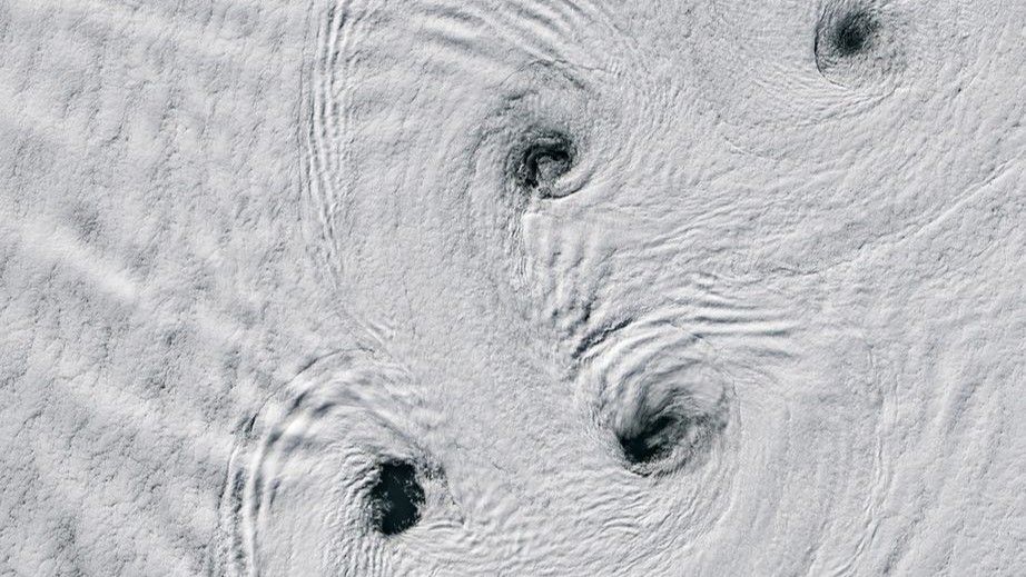
NASA’s 2026 satellite image reveals Von Kármán vortex streets near Peter I Island in Antarctica.
- NASA satellite photographed swirling vortices near Antarctic volcano in 2026
- Von Kármán vortex streets formed over snow-covered Peter I Island on Feb. 11, 2026
- Dark water gaps visible at centers of swirling snow patterns
A striking satellite image from NASA released on May 12, 2026, captures Von Kármán vortex streets near Peter I Island in Antarctica. The photograph, taken on February 11, 2026, shows symmetrical swirling patterns in the snow, with dark water visible at the centers of each vortex. These vortices form when steady winds flow around tall obstacles, creating alternating spinning eddies on the lee side of the obstruction.
The phenomenon occurs frequently over islands in polar regions where strong, consistent winds interact with landmasses. Peter I Island, a volcanic island in the Bellingshausen Sea, acts as a perfect natural obstacle for wind patterns to create these visually striking vortex streets. The image provides a rare and detailed view of this weather event in one of Earth’s most remote locations.
How Von Kármán vortex streets form
Von Kármán vortex streets are named after Theodore von Kármán, a Hungarian-American physicist who made significant contributions to aerodynamics. The formation requires specific conditions: a steady wind flow, an obstacle tall enough to disrupt the wind, and a fluid medium—like air or water—to generate the spinning eddies. In this case, Antarctica’s strong katabatic winds provided the necessary conditions as they moved past Peter I Island.
The vortices alternate in rotation direction, creating a repeating pattern that can stretch for hundreds of kilometers. This phenomenon is not unique to Antarctica; it has been observed near other islands, mountains, and even offshore oil platforms. However, the pristine, snow-covered environment of Antarctica offers a rare clear view of the effect.
Significance of the NASA image
NASA’s satellite image contributes to ongoing research in atmospheric dynamics and polar weather patterns. Scientists study Von Kármán vortex streets to better understand wind flow interactions with landmasses and their broader impact on local weather systems. The data helps improve climate models and weather prediction accuracy in remote regions like Antarctica.
The image also highlights the increasing role of satellite technology in monitoring Earth’s most inaccessible regions. High-resolution satellite imagery allows researchers to observe and analyze weather phenomena without the need for on-site presence, which is often logistically challenging in Antarctica.
The photograph joins NASA’s collection of Earth Observatory images, which aim to educate the public and support scientific research. These images provide visual evidence of dynamic processes shaping our planet’s climate and weather systems. The Von Kármán vortex streets near Peter I Island offer a compelling example of nature’s intricate patterns and the power of remote sensing technology.
What You Need to Know
- Source: Space.com
- Published: May 12, 2026 at 14:00 UTC
- Category: Science
- Topics: #space · #astronomy · #nasa · #science · #mesmerizing · #antarctic
Read the Full Story
This is a curated summary. For the complete article, original data, quotes and full analysis:
All reporting rights belong to the respective author(s) at Space.com. GlobalBR News summarizes publicly available content to help readers discover the most relevant global news.
Curated by GlobalBR News · May 12, 2026
🇧🇷 Resumo em Português
Um espetáculo natural raro e hipnótico pintou os céus da Antártida no início deste ano: vórtices de Von Kármán, fenômeno que faz o ar dançar em redemoinhos perfeitos, foram capturados pela NASA sobre a Ilha Pedro I, próximo ao continente gelado. A imagem, registrada em 11 de fevereiro de 2026, revela uma coreografia de nuvens em tons de branco sobre a cobertura de neve, criando um padrão que lembra ondas ou redemoinhos cósmicos. Embora não seja inédito, a foto destaca a beleza efêmera dos fenômenos atmosféricos em regiões extremas, onde a interação entre ventos fortes e obstáculos naturais — como ilhas ou montanhas — molda a dinâmica do clima de forma quase artística.
Para o Brasil, país com uma das maiores extensões costeiras do mundo e clima variado, a relevância dessa imagem vai além da curiosidade visual. Estudos sobre vórtices de Von Kármán ajudam cientistas a entender melhor a circulação atmosférica em latitudes médias e altas, o que pode aprimorar modelos climáticos e previsões meteorológicas — inclusive para regiões como o Sul e o Sudeste, onde sistemas de alta e baixa pressão frequentemente geram fenômenos semelhantes. Além disso, a Antártida, embora distante, influencia diretamente o clima brasileiro por meio de correntes marítimas e de ar, como a Oscilação Antártica, que afeta a distribuição de chuvas no território nacional.
A próxima missão da NASA ou de outros órgãos internacionais poderia aprofundar o monitoramento desses vórtices, combinando dados de satélites com medições em campo, especialmente em um cenário de mudanças climáticas onde padrões atmosféricos nunca antes observados ganham força.
🇪🇸 Resumen en Español
El cielo antártico se pinta de arte efímero con remolinos de nieve danzando alrededor de un volcán solitario, capturados por el ojo vigilante de un satélite de la NASA hace apenas unos meses. La imagen, que hoy destaca como foto del día en el espacio, revela un espectáculo natural donde los vórtices de Von Kármán, esos patrones simétricos que parecen pinceladas cósmicas, se forman al sur del continente helado, cerca de la remota isla Peter I.
Este fenómeno, más común en latitudes tropicales o templadas, cobra especial interés en la Antártida por su rareza y su conexión con el cambiante clima global. Los vórtices, generados por la interacción del viento con obstáculos topográficos como volcanes, no solo deslumbran por su belleza geométrica, sino que también ofrecen pistas sobre la dinámica atmosférica en uno de los entornos más extremos del planeta. Para los hispanohablantes, esta imagen sirve como recordatorio de que, incluso en los confines más inhóspitos de la Tierra, la naturaleza sigue escribiendo su propia historia con trazos imposibles de ignorar.
Space.com
Read full article at Space.com →This post is a curated summary. All rights belong to the original author(s) and Space.com.
Was this article helpful?

Discussion